Greetings!
Wow, we have already almost half of Twentyten. If this year goes any faster we might all just have to look for xmas presents soon.
Our mapper just finished the work on the first release of the Philippines map update in May and we are already working on the next release. Beside this the international team finalized additional maps for other countries around South East Asia. Download the updates from our support area [1]
We were also busy with the launch of carNAVi products in local Robinsons Appliance Stores. This will be a milestone for the drivers in our country since before it was more or less a long search to get those gadgets.
Summer is over now and it seams the rainy seasons starts as scheduled – El Nino was hot and dry, as expected, let’s hope La Nina will not bring us too much rain. However, always take your carNAVi with you, you’ll never know when you have to find a route around a flooded road.
Enjoy the read.
Your carNAVi Team
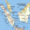 Indonesia, Malaysia and Singapore maps available
New digital maps covering Indonesia and Malaysia/Singapore are available in the carNAVi Store. These mapsets includes road maps for Indonesia and Malaysia/Singapore. The detailed road network includes major highways, highways and residential streets. Thousands of POI for most major cities are also included. Download the maps free of charge, simply visit the carNAVi Store [2]
![]() carNAVi and Robinsons Malls
carNAVi and Robinsons Malls
Both companies cooperates starting June 1, 2010 in distributing carNAVi systems in selected Robinsons Malls – first in Metro Manila and in the near future also nationwide. The launch of the carNAVi Pro BT in a digital appliance store will be held at the exhibit hall of Forum Robinsons, formerly known at Robinsons Place Pioneer, located at the corner of EDSA and Pioneer Street, Mandaluyong City. The exhibit hall is very near Robinsons Digital (the digital appliances center), Robinsons Supercenter. Mall hours are 10:00 a.m. to 9:00 p.m. Be there to witness the launch of the carNAVi Pro BT GPS Navigation system in a digital appliance store – indeed, it is an idea whose time has come!
GPS has a Positive Effect on Driving and Traffic Safety
GPS is useful for folks who have been driving for quite some time and for first-time drivers – to avoid getting lost ending up in unfamiliar/strange places. Avoid swerving (and being apprehended by the police) by prompting you way before so you can go to the proper lane. In addition, some car navigation system enables you to use your cellphone hands-free with Bluetooth technology allowing you to free up your hands for driving safely. The leading Dutch research institute TNO today announced the results of research which prove the positive influence of satellite navigation devices on driving and traffic safety.
Key findings of the research:
• The use of car navigation improves the driver’s behaviour when driving through an unknown area.
• The use of satellite navigation system heightens alertness and reduces the stress levels of the driver
• Drivers who do NOT have the use of a satellite navigation solution have 12% more damage claims
• The use of a car satellite navigation solution reduces the amount of miles driven by 16%
• The use of a car satellite navigation solution reduces travel time when driving through an unknown area to an unknown destination by 18%
• The use of a car satellite navigation solution reduces the workload (the amount of effort it takes the driver to drive) of the driver when travelling through an unknown area to an unknown destination.
 How carNAVi users can participate in updating the map data
If you drive a road, that is not in the map, just switch on the ‘Track recording’ function. You can find this in Settings – Start record track. Activate this function at the beginning of the road and the unit will now automatically save the coordinates of the track you are driving. If there are U-Turns within, set a waypoint ‘U-TURN’ there. Of course you can also send us bike trails, hiking trails etc. Everything is welcome. To stop recording, just press the red tape icon on top of the map screen.
To collect waypoints just store your waypoints wherever you are, make sure the waypoints are on the correct side of the street and not too far (5-10m) away from the road, if they are beside a road.
Name the waypoint – if the name is self explaining, like Jollibee or Shell. If the name is not selfexplaining, please note within the name also the type of the waypoint, i.e. “Tinas Restaurant, Italian”. To export your waypoints, from the Waypoints Menue you can press the Menue button (the middle one on the bottom of the screen), select Export Waypoints to save the data prefered as a .gdb file to the SD card. For uploading to your PC refer to the transfer methods explained on our website [3].
 [4] Email This Article [4]